Targeting Federal Funding to Areas Experiencing Significant Poverty (interactive graphic)
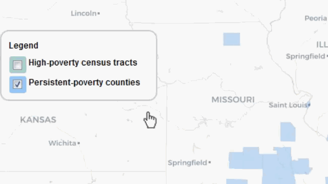
Areas with high poverty rates can face systemic problems—like higher levels of crime and school dropouts—that can make it more difficult for residents to get out of poverty. To help, some federal agencies have been required to use at least 10% of program funds in counties with poverty rates of at least 20% over the last 30 years. These “persistent-poverty counties” are predominantly rural and mostly located in the south.
Legislation proposed in 2019 would expand this requirement to more agencies and programs, and also direct additional funds to census tracts (small subdivisions of a county that average about 4,000 residents) with poverty rates of at least 20% over the past 5 years. These are called “high-poverty census tracts,” and they tend to be located in urban areas.
So, which areas of the country could receive these funds if this legislation is approved? We developed an interactive map that shows the persistent-poverty counties and high-poverty census tracts in the United States. The below figure demonstrates how the graphic works (hover over an area to see additional details). Access the complete interactive graphic at GAO.gov or by clicking on the below image.
Image
Learn more about our work on this issue by checking out our new report and podcast with GAO’s Bill Shear.
- Comments on GAO’s WatchBlog? Contact blog@gao.gov.
GAO Contacts


GAO's mission is to provide Congress with fact-based, nonpartisan information that can help improve federal government performance and ensure accountability for the benefit of the American people. GAO launched its WatchBlog in January, 2014, as part of its continuing effort to reach its audiences—Congress and the American people—where they are currently looking for information.
The blog format allows GAO to provide a little more context about its work than it can offer on its other social media platforms. Posts will tie GAO work to current events and the news; show how GAO’s work is affecting agencies or legislation; highlight reports, testimonies, and issue areas where GAO does work; and provide information about GAO itself, among other things.
Please send any feedback on GAO's WatchBlog to blog@gao.gov.