Weather Forecasting—Outlook Unclear
- The Joint Polar Satellite Program (JPSS) for
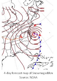 medium to long-term weather forecasts: JPSS builds and maintains a network of satellites that are key to forecasting the path and intensity of major storms. For instance, polar satellite data increased the accuracy of forecasts for “Snowmageddon” in 2010.
- The Geostationary Operational Environmental Satellite R-Series Program (GOES-R) for “Nowcasts”: GOES-R is an additional network of geostationary satellites for near-real-time data on the local effects of weather events, like the path of Superstorm Sandy in late 2012.
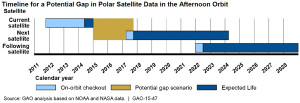 Excerpted from GAO-15-47
- Questions on the content of this post? Contact David A. Powner at pownerd@gao.gov.
- Comments on GAO’s WatchBlog? Contact blog@gao.gov.

GAO's mission is to provide Congress with fact-based, nonpartisan information that can help improve federal government performance and ensure accountability for the benefit of the American people. GAO launched its WatchBlog in January, 2014, as part of its continuing effort to reach its audiences—Congress and the American people—where they are currently looking for information.
The blog format allows GAO to provide a little more context about its work than it can offer on its other social media platforms. Posts will tie GAO work to current events and the news; show how GAO’s work is affecting agencies or legislation; highlight reports, testimonies, and issue areas where GAO does work; and provide information about GAO itself, among other things.
Please send any feedback on GAO's WatchBlog to blog@gao.gov.